
Breaking News
Snow, ice, rain and severe weather coming to central, eastern U.S.

Snow, ice, rain and severe weather coming to central, eastern U.S.
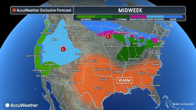
As warm air surges across much of the central and eastern United States this week, a potent storm will bring severe weather to some areas, while rounds of snow and ice linger over the northern tier. As the thaw progresses, the potential for ice jams will increase.
A series of potent storms will hammer California and parts of the West this week and into next week. These storms will traverse the northern Rockies, then emerge over the North Central states and drift into the Northeast.

AccuWeather.com
High winds to boost central U.S. wildfire risk
A storm generated strong winds from the Rockies to the Plains during the first half of this week. Gusty winds will remain across portions of the Southwest and Midwest through Wednesday night.

AccuWeather.com
Several fast-moving wildfires broke out across the region Tuesday amid strong winds. Additionally, strong winds and blowing dust may have been a factor in a deadly pileup near Pueblo, Colorado, and another multi-vehicle crash near Oakley, Kansas. A fire risk will continue into Wednesday evening.

AccuWeather.com
Snow, ice to continue to hang on
On the colder side of this storm, the heaviest snow east of the Rockies will be over the Canadian Prairies, but some accumulating snow will fall in a narrow band that extends into part of the Great Lakes region and the Northeast.
In the Central states, the heaviest snow, where a general 6-12 inches is forecast, will extend from the northern part of North Dakota to the northern part of Minnesota.

AccuWeather.com
Moderate snowfall on the order of 3-6 inches is foreseen from northern Michigan to portions of northern New York, Vermont, New Hampshire and Massachusetts at midweek.

AccuWeather.com
On the southern edge of the snow, pockets of freezing rain and sleet will form. Through Wednesday, this zone will extend from parts of northern Michigan to central New York and central New England.

AccuWeather.com
Severe weather threat to increase Thursday
South of the ice, rounds of rain and even thunderstorms are expected.
Since the first storm system is forecast to weaken as it moves eastward over the Midwest, thunderstorms with it farther south over the Midwest may be limited Wednesday. However, there may still be a few locally severe storms Tuesday night in southern Michigan.
As a second, and likely stronger, storm rolls across the North Central states from Wednesday to Thursday, the likelihood of severe weather will be significantly higher. Thursday’s severe weather threat includes the potential for multiple tornadoes.

AccuWeather.com
“If this pans out the way we are concerned for severe weather on Thursday, it could be a nasty spring snap back in an area that was adversely affected by snow and ice in recent weeks,” AccuWeather Chief Meteorologist Jon Porter said.
The combination of an ongoing thaw and rain over portions of the Midwest, the central Appalachians and parts of the Northeast will increase the potential for ice jams and ice jam flooding with the two storms this week.
Above-freezing temperatures during the day and below-freezing temperatures at night, for the most part, have allowed a more gradual thaw to occur up until this week.

AccuWeather.com
But as longer-duration warmth leads to more snowmelt, the surge of water entering streams and rivers may trigger a rapid breakup of the ice cover. Where ice jams occur, there is a risk of significant flooding in unprotected areas upstream of the jams.

AccuWeather.com
Ice fishermen are urged to be extremely cautious this week, as ice cover on lakes may begin to break, potentially preventing an exit to shore.
Where warm, moist air flows over cold ground and snow or ice cover, dense fog may form, further aggravating travel in the Midwest and Northeast this week.
On the backside of the second storm this week, a band of accumulating snow will extend from Wyoming and Nebraska to northern Michigan from Thursday to Friday.

AccuWeather.com
The snow coming to part of the Plains will help to ease the wildfire threat.
Watching for an East Coast winter storm this weekend
It is possible a storm that swings through the Midwest and Northeast this weekend could track cold enough to bring snow to parts of the Ohio Valley, central Appalachians and coastal Northeast.
Want next-level safety, ad-free? Unlock advanced, hyperlocal severe weather alerts when you subscribe to Premium+ on the AccuWeather app. AccuWeather Alerts™ are prompted by our expert meteorologists who monitor and analyze dangerous weather risks 24/7 to keep you and your family safer.