
Breaking News
Latest path shows Category 1 storm will move across Atlantic this weekend, ‘dangerous’ surf swells and coastal flooding still expected
Hurricane Erin is in the first stages of transitioning into a post-tropical storm, the National Hurricane Center reported Friday morning. While there are no coastal watches or warnings in effect anymore, “swimming at many U.S. East Coast beaches is likely to remain dangerous for a couple more days,” the NHC said.
Erin is currently a Category 1 storm but remains a very large hurricane. Erin’s center is expected to start moving quickly across the North Atlantic Ocean early Saturday morning.
Even as Erin continues to move northeastward, the NHC noted, surf swells generated by the storm could still affect the Bahamas, Bermuda and the U.S. East Coast over the weekend. Coastal flooding is expected through tonight, which could still impact areas like the Outer Banks in North Carolina.
North Carolina Highway 12 is the primary road that connects the islands in the Outer Banks and separates the Sound side from the Atlantic Ocean side. It’s expected to be torn up and washed out in several places from the impacts of Erin, which could isolate villages for days or even weeks.
Erin formed in the eastern Atlantic Ocean last week, officially reaching hurricane status on Aug. 15. It is the first hurricane of the 2025 Atlantic season.
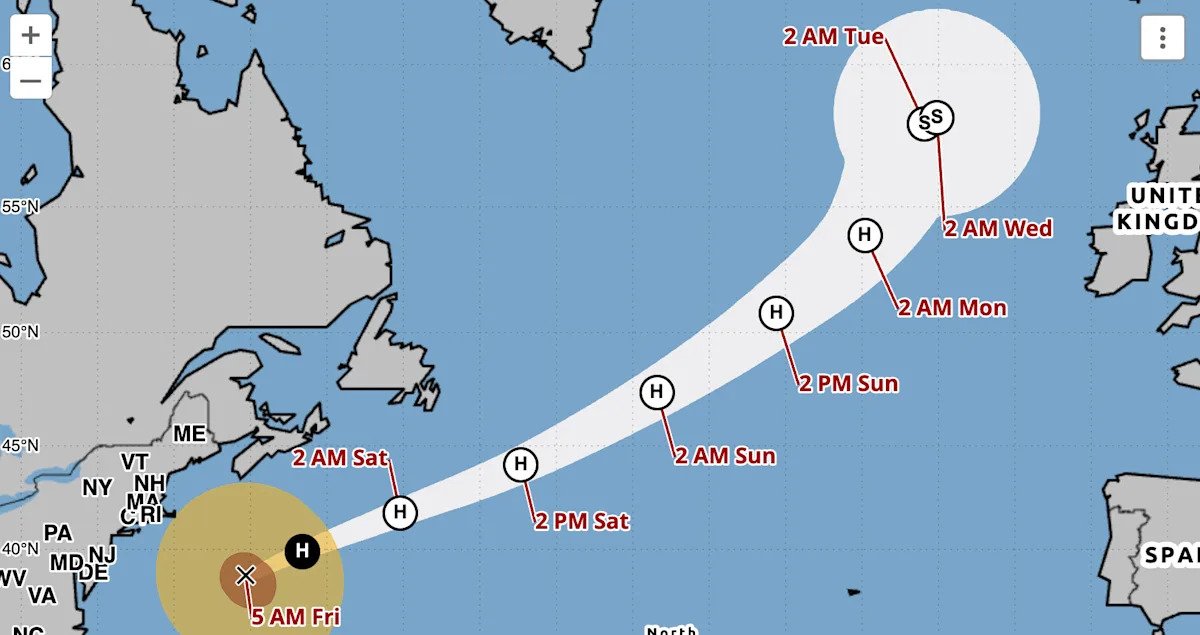
Where is Hurricane Erin now, and what is its path?
As of 5 a.m. ET Friday:
Erin was located about 435 miles north of Bermuda and about 425 miles south-southwest of Halifax, Nova Scotia.
The storm has maximum sustained winds of 90 mph, making it a Category 1 hurricane.
It’s moving in a northeast direction at 22 mph.
According to the NHC’s latest advisory, Erin will keep moving east-northeast throughout Friday and over the next few days. It’s expected to increase in forward speed, with even more acceleration this weekend.
The NHC forecast track shows that Erin’s center will pass Atlantic Canada on Friday before crossing the north Atlantic Ocean. It’s likely Erin will become a post-tropical storm by Friday night.
Watches and warnings
As of 5 a.m. ET Friday morning, there are no coastal watches or warnings in effect. The Bermuda Weather Service has discontinued its tropical storm warning.
What do watches and warnings mean
Throughout the week, storm surge warnings and tropical storm warnings were in effect for areas along the North Carolina and Virginia coasts and Bermuda. As of Friday morning, those watches and warnings are no longer in effect.
A storm surge warning means there is a danger of life-threatening inundation from rising water moving inland from the coastline. A tropical storm warning is issued when tropical storm conditions, such as sustained winds up to 73 mph, are expected.
What are the chances Erin will intensify?
Hurricanes are rated on the Saffir-Simpson Hurricane Wind Scale, ranging from Category 1 to Category 5, with 5 being the most severe. A storm is considered a major hurricane when it reaches Category 3 strength, with sustained winds of at least 111 mph.
Erin reached Category 5 strength on Aug. 16 before weakening on Tuesday. It is currently a Category 1 storm, with maximum sustained winds of 90 mph.
“Erin remains a very large hurricane,” NHC said Friday morning.
Hurricane-force winds extend outward up to 125 miles from its center, and tropical-storm-force winds extend outward up to 370 miles.
How is hurricane season shaping up?
The 2025 Atlantic hurricane season, which began June 1 and runs through the end of November, has a 50% chance of being above normal.
Earlier this month, forecasters at the National Oceanic and Atmospheric Administration slightly updated the number of expected storms to 13 to 18 (estimated at 13 to 19 in May), of which up to five could become major hurricanes (with winds of more than 111 mph).
A typical hurricane season averages 14 named storms. We’re currently about halfway through this year’s Atlantic hurricane season, and as of Aug. 15, there have been five so far: tropical storms Andrea, Barry, Chantal and Dexter, and now Hurricane Erin.