
Breaking News
January polar vortex forecast warns of 2 Arctic blasts
Our old wintertime friend the polar vortex is set to funnel bitterly cold air south from Canada two more times in January, once over the weekend of Jan. 17 and again about a week later.
“This first shot of cold air over the weekend and into early next week looks to be the appetizer, with the main course of cold coming the following week,” said AEM climatologist Judah Cohen in an email to USA TODAY on Jan. 14. “I think there is potential for the second round of cold air to be more extreme.”
Another expert, Weather Trader meteorologist Ryan Maue agreed, noting this week that although “this is two weeks in the future, so the details and intensity will change, but we are poised to see a potentially historic Arctic ‘polar vortex’ blast across North America into the end of January.”
A ‘stretched’ polar vortex
The polar vortex is not a storm − it’s a large-scale, persistent area of low pressure and extremely cold air that sits high in the atmosphere over both of Earth’s poles, according to the National Weather Service. It exists year‑round, but it strengthens in winter when polar temperatures drop, and weakens in summer.
When the vortex is strong, that cold air stays bottled up over the poles.
However, when the vortex weakens, stretches or becomes disrupted, pieces of that unspeakably cold air can spill southward into the U.S., Europe or Asia, producing outbreaks of frigid Arctic air. That’s what is happening in January.
According to Cohen, we will have one polar vortex stretch in mid-January. That stretch will return below normal temperatures to the Eastern U.S.
Recently, much of the cold air in North America was erased with the strong (but more importantly circular) polar vortex during the beginning of January, which allowed mild Pacific air to flood much of Canada and the U.S. The polar vortex will relax briefly before the next stretch starting as the last week of January nears.
At that time, “the polar vortex stretch will start out in western North America and quickly slide east. This looks to resupply the cold air in Western Canada that we saw for much of December before heading southeast into the North-Central U.S. and eventually the Northeastern U.S. the fourth week of January,” Cohen said.

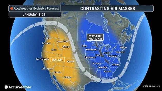
Waves of Arctic air are forecast to continue spreading across the eastern half of the nation from Jan. 15-25. At the same time, the West will stay warm.
What does this mean for snow, cold temperatures?
Snow is the $64,000 question, Cohen told USA TODAY. “Looks like the usual spots will continue to see the snow, the lake effect regions around the Great Lakes and Northern New England. Whether it will snow much in the big cities is a tough call. I think that the pattern will eventually start to produce more widespread snow but it’s not obvious. In the meantime, it again looks like more nuisance-type snows from Alberta Clippers.”
According to AccuWeather, because of the large, rounded shape of the jet stream dip, it will be difficult for storms in the South to rapidly strengthen along the Atlantic coast and become major snowstorms.
“Instead, most storms will stay weak, move quickly and exit out to sea through much of next week,” said AccuWeather meteorologist Alex Sosnowski in an online forecast. “However, any fluctuation, even brief, could be enough to allow a southern storm to track farther north and hug the Atlantic coast.”
Meanwhile, temperatures in Chicago are expected to swing from near average to 10-20 degrees below average over the next one to two weeks, AccuWeather said. The average high in Chicago is near 32 degrees Fahrenheit.
In New York City, temperatures will range from near the historical average in the upper 30s to 5-10 degrees below during the same period as the polar vortex takes hold.
This article originally appeared on USA TODAY: January 2026 polar vortex forecast warns of 2 Arctic blasts