
Breaking News
Storm intensifies to Category 4; see its path and the latest forecast
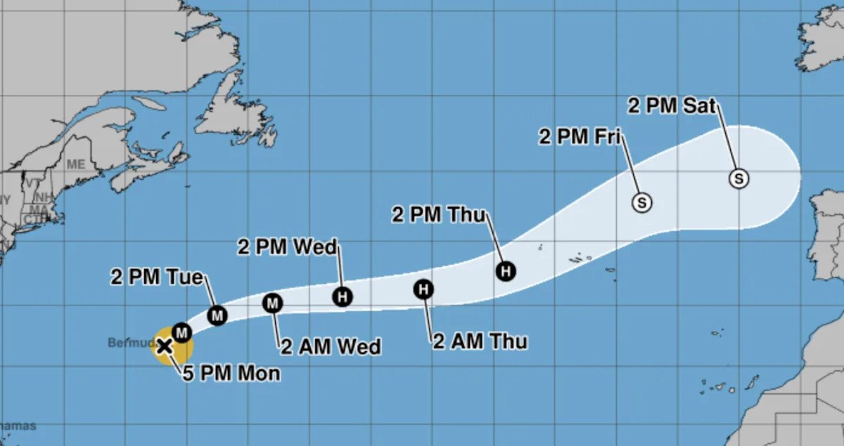
Hurricane Gabrielle has rapidly gained strength over the past 36 hours, becoming a Category 4 hurricane on Monday evening. The storm, which strengthened into a hurricane on Sunday afternoon, is expected to sustain its power overnight as it tracks eastward over the Atlantic Ocean.
Earlier forecasts had suggested that Gabrielle may be on a path straight toward Bermuda, but more recent predictions have it passing well to the east of the island nation. The storm is expected to continue to create dangerous tidal conditions on the islands for the next few days. Parts of the East Coast of the United States may also experience “life-threatening surf and rip current conditions,” according to the National Hurricane Center.
Where is the storm now, and what is its path?
As of 5 p.m. ET on Monday:
Gabrielle is currently located around 180 miles east-southeast of Bermuda.
It has maximum sustained winds of 140 mph (Category 4 hurricanes have sustained winds of 130-156 mph).
It’s moving north-by-northeast at 12 mph.
The storm is expected to head in a northeastward direction as it makes its way back across the Atlantic over the next few days.
How strong will Gabrielle become?
Forecasters expect “little significant change” in Gabrielle’s strength through the rest of Monday. The storm is expected to start weakening on Tuesday but is forecast to maintain hurricane-force winds throughout the week. The most recent forecast puts Gabrielle on a path to reach the Azores in the eastern Atlantic while still at hurricane strength by Thursday. The National Weather Service says it’s “too soon to specify” the true risk facing the Azores at this time.
Are more storms developing?
The NWS is currently tracking two systems in the eastern Caribbean that could develop into tropical depressions in the coming days. One system is considered to have a roughly 50% chance of developing, while the second has been given an 80% chance. At the moment, there’s no indication that either system is on track to become a hurricane.
Forecasters are also monitoring Tropical Storm Narda off the Pacific coast of Mexico. Narda is expected to become a hurricane by Tuesday as it tracks westward over the open ocean. Current projections have it reaching a Category 2 by the middle of the week.
How is hurricane season shaping up?
Government forecasters anticipated an “above-normal” Atlantic hurricane season this year, with between five and nine hurricanes.
Gabrielle is the seventh named storm and the second hurricane of the season, which started in June and runs through the end of November. The first was Hurricane Erin, an incredibly powerful storm that reached Category 5 last month. Erin caused nine deaths in the island nation of Cape Verde off the western coast of Africa, but turned northward before reaching the U.S. mainland. Though Erin never made landfall, the storm caused significant flooding along the East Coast and created rough seas that caused at least two deaths along beaches in the Northeast.
Even an above-average hurricane season this year would be a relief compared with 2024, which featured multiple devastating hurricanes that struck the Gulf Coast. Hurricane Helene caused at least 250 deaths and led to catastrophic flooding throughout the Southern U.S. when it struck in late September last year. Less than two weeks later, Hurricane Milton — one of the most intense Atlantic hurricanes ever — pummeled Florida.