
Breaking News
Severe Weather Outbreak With Widespread Damaging Winds, Tornadoes Continues In East Monday
Severe weather is ongoing in parts of the South, Midwest and East through Monday with a threat of widespread damaging winds and tornadoes all possible.
This severe outbreak is happening on the warm side of a winter storm, named Iona by The Weather Channel. It has dumped several feet of snow in the Midwest and causing severe weather in the South.
More than 300 reports of severe weather occurred on Sunday, mainly from wind. One tornado was reported in Arkansas, and that number could go up as meteorologists survey the damage.
Monday’s threat will bring all modes of severe weather: damaging winds, large hail and tornadoes.

(FORECAST: Upper Midwest Blizzard This Weekend Into Monday)
Happening Now
Severe thunderstorms are ongoing, taking the form of a squall line, a long line of severe thunderstorms. Damaging winds over 75 mph are expected within this squall line, but some embedded tornadoes are expected. There is even a chance for a couple strong tornadoes of EF2 or greater.
Below is the current radar:

Monday
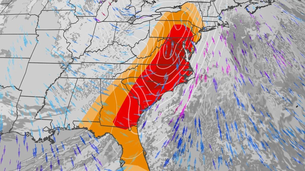
As the cold front from the intense Great Lakes low surges east, thunderstorms with damaging winds will be widespread Monday across much of the East, from northern Florida to the Northeast. This includes 60 million people across the East under the threat of severe weather.
For now, NOAA’s Storm Prediction Center has highlighted the area with the highest chance of severe weather from parts of the mid-Atlantic states to the Carolinas.

Even a few tornadoes are possible Monday, either embedded in the squall line, or in any discrete rotating thunderstorms that could flare up ahead of the line. Again, some could even be EF2 or greater.
We could also see hail greater than 2 inches in diameter.
Power outages and tree damage could be widespread in the East Monday and Monday night.

This severe outbreak is the third time this month that a rash of severe thunderstorms is in the forecast. It is affecting some areas that have been hit repeatedly by severe weather in one or both of the previous outbreaks from March 5-8 and March 10-12.
Prepare Now
– Prepare for a possible power outage, especially if it’s forecast to turn cold after the storm.
– Have multiple ways of receiving official National Weather Service watches and warnings including via smartphone and NOAA weather radio. Make sure alerts are enabled so you can be awakened, if sleeping.
– Know where to seek shelter when a severe thunderstorm or tornado warning is issued. If you live in a manufactured home, a community storm shelter, a nearby home or other substantial building is the safest choice.
– Move to shelter immediately when a warning is issued. Don’t waste precious seconds looking out the window.
– Take severe thunderstorm warnings as seriously as tornado warnings. Winds over 60 mph are capable of downing trees on vehicles, homes and buildings, an underrated danger in high wind events.
(MORE: 14 Severe Weather Safety Tips)
Jonathan Erdman is a senior meteorologist at weather.com and has been covering national and international weather since 1996. Extreme and bizarre weather are his favorite topics. Reach out to him on Bluesky, X (formerly Twitter) and Facebook.