
Breaking News
New spring 2026 forecasts warn of the dreaded ‘heat dome’
Spring officially arrived Friday, March 20, and new forecasts say it’s shaping up to be a warm few months for most Americans.
The news comes as much of the Western U.S. has already been enduring a summer preview from a huge, record-smashing heat dome across the region, which has sent tens of millions running for the air conditioner and the pool.
Meanwhile, drought conditions are forecast to worsen or develop for many areas in the West and south-central Plains, according to NOAA’s Spring Outlook released March 20 for April through June.

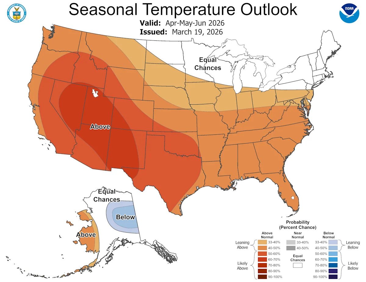
The national temperature forecast map for April-May-June shows widespread above-average temperatures are forecast for much of the nation, especially in the West.
What’s the spring forecast for the US?
According to NOAA’s Climate Prediction Center (CPC), the April-May-June 2026 temperature outlook favors above-normal seasonal temperatures for much of the contiguous United States, with the exception of parts of the northern Plains, upper Mississippi Valley, Great Lakes and Northeast.
“The highest probabilities (greater than 60 percent) of above-normal temperatures are forecast for areas of the central Great Basin and Rockies to parts of the Southwest,” the CPC said in an online forecast.
As for precipitation, the April-May-June 2026 outlook shows below-normal seasonal precipitation amounts for the Pacific Northwest, much of the Intermountain West and Rockies as well as areas in the central High and Great Plains.
Meanwhile, above-normal precipitation is favored for most of western Alaska and for a region that includes the eastern Great Lakes, the mid-Atlantic and parts of the Southeast, according to the CPC.

The spring precipitation forecast map shows ongoing dryness continuing in the West and a wetter-than-average spring in much of the East.
What part of the nation will be hottest this spring?
The highest odds for above-normal temperatures, including potential extreme heat episodes, are for the interior West, the central and southern Rockies, the Southwest, and the central and southern Plains, said Jon Gottschalck, the chief of the operational prediction branch at NOAA’s Climate Prediction Center, in an email to USA TODAY.
What about spring flooding?
The overall flood risk across most of the continental U.S. for spring 2026 is currently assessed as normal to below normal, NOAA said in a statement. This risk determination was made primarily because of a dry and warm winter that resulted in dry soils over much of the eastern U.S., mitigating the threat of rainfall-driven flooding. Additionally, a well-below-normal snowpack across most of the country will reduce the risk of snowmelt-driven flooding.
However, the Red River of the North and the lower Ohio Valley typically experience flooding annually; therefore, flooding is anticipated in these basins this year as well, NOAA said.
“We anticipate typical spring flooding this year over portions of the Greater Mississippi River Basin, but the risk for widespread significant flooding is low,” said Ed Clark, director of NOAA’s National Water Center, in a statement. “However, it is crucial to remember that heavy rainfall has the potential to lead to a major flooding event.”
Typical spring pattern in the Midwest, Northeast as heat dome expands in the West
For the immediate future, AccuWeather said that cold and warm air will trade places multiple times across the Midwest and Northeast in the coming weeks, a pattern typical of spring.
The next rebound in temperatures is already underway in parts of the Midwest and will spread to portions of the Northeast into the weekend as the edge of a massive, record-smashing heat dome in the Southwest expands.
The western heat dome has already broken the record for hottest March day in U.S. history as temperatures soar into the 90s and even past 100 degrees in some cities, levels more typical of late spring or early summer, AccuWeather said.
Is this the end of winter weather, Arctic blasts?
“No, not entirely, in fact areas near the Great Lakes and parts of the Northeast are forecast to see below-normal temperatures during the middle of next week with some areas seeing a short period of low temperatures in the upper teens and low 20s, with lower wind chills and some potential for snow,” said Gottschalck.
“But certainly not bitter Arctic air like earlier in the year.”
“Having said that, looking ahead past next week, we generally see above normal temperatures for most of the country and so by that time − mid April, any major, extensive impactful cold air periods are unlikely,” Gottschalck said.
What is a heat dome?
.oembed-frame {width:100%;height:100%;margin:0;border:0;}
A heat dome, like the one baking the West now, is a sprawling area of high pressure that promotes hot and dry conditions for days or weeks at a time.
“Heat domes are a lot like a balloon,” AccuWeather senior meteorologist Alan Reppert explained. “They expand and contract as the day goes by, and when you are inside of it, it can be very warm.”
Heat domes can also prevent clouds from forming, resulting in abundant sunshine that boosts temperatures, potentially toward record levels.
As temperatures swell, so too does the cooling demand which can increase the strain on the power grid of an entire region. Extended hot and dry spells can also cause drought conditions to develop or worsen, AccuWeather said in an online report.
AccuWeather meteorologist Tom Kines told USA TODAY in an email that “one concern we have about this early season heatwave across Southern California is it will cause the ground cover to brown up much earlier than usual, which could spell trouble/increase the fire danger if there is a Santa Ana event at some point in April or May.”
What are some of the dangers associated with heat domes?
As with any heat wave, heat stroke, heat exhaustion and heat cramps are common dangers, Kines said. “Drink plenty of fluids − ideally water − and wear light-colored and lightweight clothing. A hat with a visor or better yet one with a wide brim to shield the sun from your head.”
“If possible, do your outside work or strenuous activities early in the day or evening when it’s not so hot and the sun is less intense. Air conditioning and a pool are two of the best ways to beat the heat.”
Is this a good example of a heat dome?
This is definitely an example of a heat dome. Heat domes are associated with a stagnant air mass and record-challenging heat, Kines said.
“The records being broken with this heat dome aren’t being broken by a degree; they are being obliterated by a few and in some cases several degrees. Since this heat is occurring so early in the season, most people’s bodies have not been acclimated to the heat yet,” he added.
How long will this heat dome last?
Kines said the heat dome will begin to break down early in the week of March 23. However, temperatures are likely to remain above the historical average.
Could we see more ‘heat domes’ this spring?
“Yes, this is likely. Not only do short term climate prediction numerical models favor widespread above-normal temperatures as forecast, there is strong agreement for this among many models and at higher than normal odds,” Gottschalck told USA TODAY.
More: Can we blame El Niño or La Niña for March’s crazy weather?
This article originally appeared on USA TODAY: NOAA releases spring 2026 forecast that looks a lot like summer