
Breaking News
Hurricane Melissa forecast to become a rare Category 5 tonight, seek shelter now in Jamaica
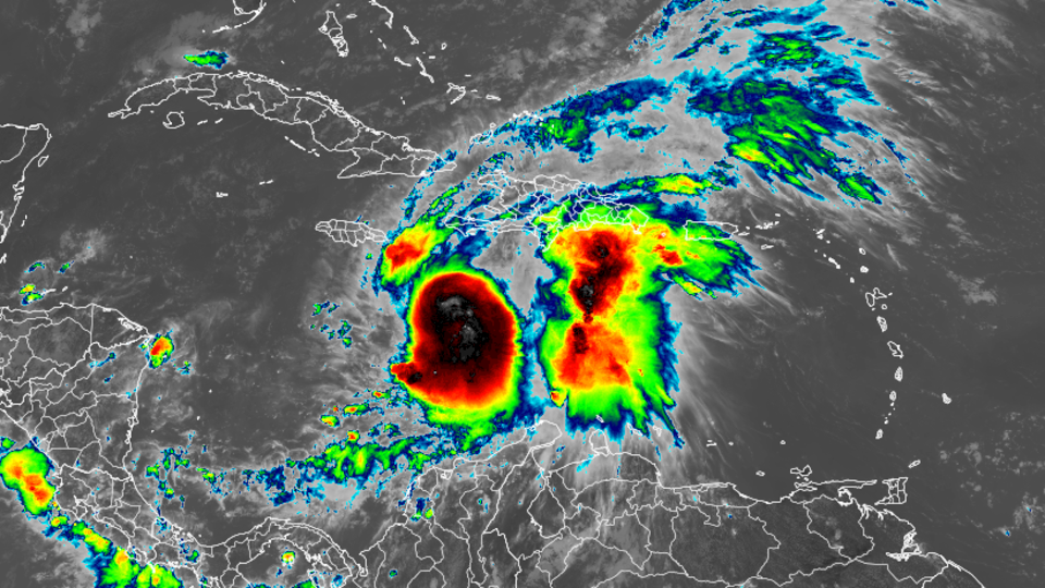
Melissa rapidly intensified going into Sunday morning and is now a Category 4 hurricane with 140 mph winds. The US National Hurricane Center expects it to strengthen into a rare Category 5 hurricane on Sunday night or early Monday.
The center of the hurricane is located 110 miles south of Kingston, Jamaica and the storm is moving westward at just 3 mph.
Those in Jamaica need to “seek shelter now ,” the NHC said Sunday morning. “Damaging winds and heavy rainfall today and on Monday will cause catastrophic and life-threatening flash flooding and numerous landslides before potentially devastating winds arrive Monday night and Tuesday morning.”
Torrential rains are impacting portions of Haiti and tropical storm conditions are likely occurring in Jamaica. Heavy rainfall will last for several days, bringing life-threatening, potentially catastrophic impact.
“I urge Jamaicans to take this weather threat seriously,” said Jamaican Prime Minister Andrew Holness. “Take all measures to protect yourself.”
Jamaica looks to be the epicenter for the worst of Melissa’s triple threat of extreme rainfall flooding, wind damage and storm surge. Melissa could make landfall on Jamaica late Monday or early Tuesday. Haiti also continues to be in thick of Melissa’s destructive flood and landslide threats.
A hurricane warning is effect for Jamaica, where hurricane conditions are expected by Monday. Southern Haiti and portions of Cuba are under a hurricane watch.
Melissa has been moving at a snail’s pace for days and it won’t pick up speed anytime soon as it tracks generally westward through Sunday night.
That slow movement has already caused problems. Torrential rain bands have swamped Haiti and the Dominican Republic for much of the week, causing flooding and triggering landslides. At least three deaths have been reported in Haiti due to the storm, two of which were the result of a landslide, the Haitian Civil Protection Agency said in a statement. In the Dominican Republic, at least one person has died and more than 1,000 people have evacuated or been displaced, officials said Friday.
Melissa is expected to continue to intensify Sunday, ramping up its destructive wind and storm surge threats alongside the intense rain as it tracks near or south of Jamaica through early week. Landfall as a Category 4 hurricane is expected, but a Category 5 landfall cannot be ruled out and Melissa could be the strongest hurricane on record to make landfall in Jamaica.
This explosive strengthening is happening more often as the world warms due to fossil fuel pollution. Three of the four Atlantic hurricanes this season underwent extreme rapid intensification: Erin, Gabrielle and Humberto.
Melissa’s extreme threats
Jamaica, Haiti and the southern Dominican Republic will face the worst of the storm into at least early next week. Next in line for strong winds, storm surge and flooding rain will be eastern Cuba, the southern Bahamas and Turks and Caicos.
Rainfall totals up to 40 inches are expected from Melissa in parts of southern Hispaniola and Jamaica through Tuesday, with local maxima of 40 inches. Eastern Cuba could receive totals of up to 20 inches.

CNN Weather
“Extensive damage to roads and buildings is expected, potentially isolating communities for an extended period of time,” in Haiti on Saturday, the hurricane center warned. “This is a life-threatening situation and immediate preparations to protect life and property should be taken.”
Jamaica will not only endure Melissa’s torrential rain, but will also have to contend with days of ferocious winds. The most extreme winds will likely occur as Melissa tracks near Jamaica on Monday into Tuesday. Downed trees, power outages and structural damage could be widespread.
Officials in the country are already preparing for the worst. All public hospitals have been in “emergency mode” since Thursday evening, halting outpatient and elective procedures to ensure more beds are open, according to Christopher Tufton, Jamaica’s Minister of Health and Wellness.
Jamaica’s airports are closing. Norman Manley International Airport closed after its last scheduled arriving flight at 8 p.m. local time (9 p.m. ET) Saturday evening, according to Daryl Vaz, the minister of transport. The Sangster International Airport plans to close at noon on Sunday.
“There is nowhere that will escape the wrath of this hurricane,” Evan Thompson, the principal director of Jamaica’s Meteorological Service, said Saturday. “It’s going to sit there, pouring water while it’s barely moving and that is a significant challenge… as long as what is predicted does take place.”
Peak storm surge heights could reach 9 to 13 feet above ground level, near and to the east of where the center of Melissa makes landfall. Storm surge will also be accompanied by large and destructive waves.
“Now is the time to secure your home, check your roof, windows, and surroundings. Use sandbags or plywood where needed and clear any overhanging branches safely,” Holness, the prime minister, wrote on X. “If you live in a flood-prone area, take protective measures and have an evacuation plan ready”
Jamaicans who spoke with Reuters on Saturday acknowledged the danger of a slow-moving hurricane, contrasting Melissa’s sluggish pace to Hurricane Beryl.
“Slow movement still cause a lot of damage, right?” said fisherman Clive Davis in Kingston. “Different from Beryl cause Beryls come with a speed and never stay too long. Just sweep through. But this now, she wants to come stay, visit Jamaica for 3 days, why?”
“It’s gonna slow down business, but it’s nature,” Davis added. “We can’t fight against nature, right?”
Into Saturday, workers in Kingston dredged as much trash and silt as they could from the bottom of Sandy Gully, an approximately 20 km long waterway snaking along the city’s western flank. When Melissa brings its months’ worth of rain as it passes over Jamaica, the swollen, debris-filled gully could knock out bridges, splitting Kingston in two.
The United States mainland is not expected to be directly threatened by Melissa. Even so, rough surf and rip currents could spread along the US East Coast next week.
Why Melissa’s forecast is so alarming
It’s barely moving. When a storm crawls, rainfall piles up over the same towns for days. A similar setup produced catastrophic floods in 2017 with Hurricane Harvey, which dumped over four feet of rain on parts of Texas, and in 2019 with Hurricane Dorian, which dropped nearly two feet of rain in the Bahamas and over a foot in parts of South Carolina.
Mountains magnify the flood threat. Haiti, Jamaica and the Dominican Republic’s steep terrain will force air upward, wringing out more moisture from the storm, just like squeezing a wet sponge, turning tropical humidity into torrents racing downhill. Mudslides are all but guaranteed in this scenario. This happened when Hurricane Helene devastated western North Carolina last year.
Heat in the Caribbean Sea runs deep. The Caribbean’s exceptionally-warm water extends far below the surface, preventing the usual “stirring up” of cooler water that can weaken hurricanes. Melissa is expected to feast on that deep reservoir of heat, raising the ceiling on its potential intensity.
Hurricane Beryl in July 2024 was the last storm to heavily impact Jamaica. It did not make landfall, but still lashed the island with flooding rain and strong winds as it passed to the south as a Category 4.
As this tricky forecast comes into focus, all signs point to Jamaica being ground zero for what could become one of the most destructive hurricanes of the season.
CNN Meteorologists Briana Waxman, Mary Gilbert and Linda Lam, along with reporters Billy Stockwell and Max Saltman contributed to this report.
For more CNN news and newsletters create an account at CNN.com