
Breaking News
Flash flood dangers far from over as storms reload across US
High humidity levels, summer heat and long days will combine to produce conditions favorable for drenching thunderstorms leading to additional flash flooding in the coming days in the eastern, central and southwestern United States, AccuWeather meteorologists warn.
There has been a swarm of flash flooding incidents in several parts of the U.S. in recent weeks. Anytime there is a great amount of moisture in the atmosphere and a front, storm, or jet stream fluctuation occurs, tremendous rainfall can be released.
“Slow-moving thunderstorms with torrential rain are a frequent trigger for flash flooding in the United States, especially during the warmer summer months when the amount of moisture in the atmosphere peaks,” AccuWeather Vice President of Forecast Operations Dan DePodwin said.
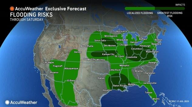
AccuWeather meteorologists have outlined flash flooding trouble spots for the days ahead.

AccuWeather.com
Some areas recently hit by flooding may be impacted again, while other regions could face heavy rain for the first time in this pattern. A few spots, like Central Texas, are expected to catch a break. Multiple weather systems will contribute to the ongoing flood risk across different parts of the country into next week.
Tropical threat grows in the Southeast as flood risk intensifies
A tropical rainstorm will travel along the north-central Gulf coast into Thursday. As this occurs, the tropical rainstorm may evolve into a tropical depression or tropical storm. Regardless, tremendous rainfall will be unleashed where it moves inland and stalls over the Gulf Coast states.

AccuWeather.com
Dangerous and destructive flash flooding and rises on area rivers are anticipated as inches of rain pour down from midweek to this weekend, with the apex likely to be in Louisiana and western Mississippi.
GET THE FREE ACCUWEATHER APP
Central U.S. faces back-to-back flash flood threats
Another area at risk for flash flooding-due to a similar setup as in the Northeast-will stretch from southern Nebraska to part of western Michigan and includes the metro areas of Chicago and Rockford, Illinois; Milwaukee, Green Bay and Madison, Wisconsin; Des Moines and Davenport, Iowa. This risk will span through early Thursday.

AccuWeather.com
After a lull from later Thursday to Friday, a new risk of torrential downpours will follow for the weekend in a large part of this area and will likely be accompanied by severe thunderstorm activity in some locations.
Tropical moisture from the storm near the Gulf coast is forecast to be pulled northward during the weekend. At the same time, a frontal zone will be stretched from northwest to southeast from the northern Plains to the Ohio Valley.

AccuWeather.com
Rainfall of 1-4 inches is forecast in parts of the Midwest from this weekend to early next week with locally higher amounts. The AccuWeather Local StormMax™ rainfall for this area is 10 inches.
The repeating nature of downpours and thunderstorms in this zone can lead to flash flooding in urban areas and quick rises along some small streams.

AccuWeather.com
“The flooding could be significant in places that have already been soaked this month and then receive multiple rounds of drenching thunderstorms this weekend,” AccuWeather Vice President of Forecast Operations Dan DePodwin warned.
Southwest
A wedge of hot, dry air should protect flood-devastated areas of Central Texas for a string of days into this weekend. However, a thunderstorm downpour zone will exist farther to the west, and a tropical rainstorm will approach the central Gulf Coast states.
“As a storm in the jet stream moves northward from Mexico, it will result in a surge of thunderstorm activity in Arizona, New Mexico and Colorado and possibly as far to the west as Nevada and southeastern California as the week progresses,” AccuWeather Senior Meteorologist Chad Merrill said.

AccuWeather.com
The setup is part of the North American monsoon, but with a boost from the jet stream storm.
Throw in the arid and rugged landscape, the risk of flash flooding of arroyos, and small streams will increase substantially, Merrill explained. The flash flood risk will not be limited to recent burn scar locations.
Along with some fluctuation from year to year, the number of flash flood incidents is likely to continue rising.
“The combination of urban development, reduced permeable land surfaces, aging/outdated drainage infrastructure, and a warming climate capable of holding more atmospheric moisture is accelerating the frequency and severity of flash flood events across many parts of the nation,” DePodwin said.
Want next-level safety, ad-free? Unlock advanced, hyperlocal severe weather alerts when you subscribe to Premium+ on the AccuWeather app. AccuWeather Alerts™ are prompted by our expert meteorologists who monitor and analyze dangerous weather risks 24/7 to keep you and your family safer.