
Breaking News
Second of three storms spreads wintry mix across Ohio Valley, targets Midwest and Northeast with snow and ice
Round two of a three-storm sequence is bringing a wintry mix across the Ohio Valley, continuing a multi-day stretch that will impact millions across more than 25 states in the winter-weary Midwest and Northeast with snow and ice.
As the first wave brought snow across the Northern Tier, it is now followed by a second system, starting in the Midwest and impacting the Mid-Atlantic on Monday, with the final wave arriving on Tuesday, primarily focusing on the Northeast and Mid-Atlantic.
Three Rounds Of Winter Storms Kick Off This Weekend, Targeting Millions In Midwest, Northeast With Snow, Ice
Winter Weather Alerts have been issued for parts of Nebraska, Missouri and Kansas through Monday morning, while new alerts have expanded east into Virginia through Tuesday morning.
While major impacts are unlikely, the system may cause minor travel disruptions as far east as Washington, D.C., before delivering a final round of snow and ice to New England.
Just as the first wave ended, a second system developed along the tail end of the passing cold front.
What Does The Wind Chill Mean?
A wintry mess will continue to spread a mix of snow and ice into the Ohio Valley, reaching the Mid-Atlantic Monday morning, as it began as light ice across parts of the Mid-Mississippi Valley and is now expanding east across the Ohio Valley.
The FOX Forecast Center said the system is forming along a stalled front and riding over a shallow but stubborn layer of arctic air at the surface.
Rare Split In Polar Vortex To Usher In Warm Weather Across Winter-weary Eastern Us Near Beginning Of March
And with warmer, moisture-rich air moving in above that cold layer, it is setting the stage for multiple precipitation types, already causing snow to transition to sleet and freezing rain in southern areas.
March Weather Outlook: Warmer Temperatures, Severe Storm Threats On The Horizon As We Spring Into Next Month
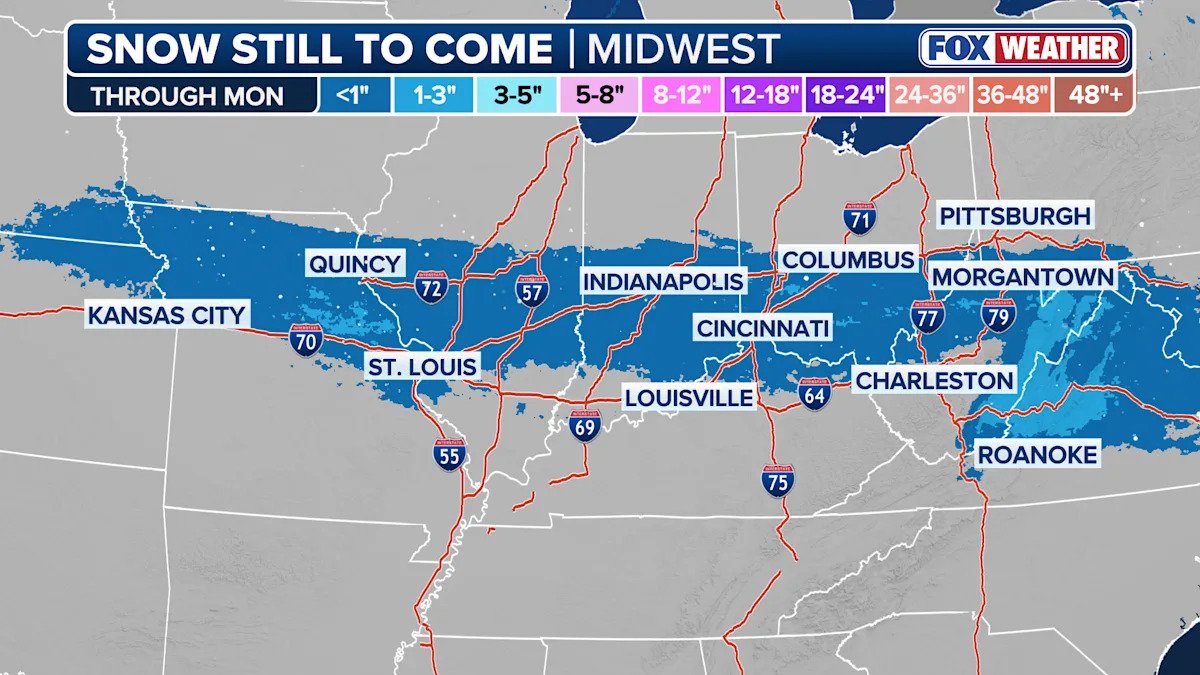
The steadiest snow in the Ohio Valley will fall Monday morning before tapering off, with a narrow stripe of 2–3 inches and ice accretion up to a tenth of an inch possible.
Beyond Monday morning, the focus for wintry weather shifts east into the Mid-Atlantic as the system tracks toward the coast, according to the FOX Forecast Center.
Light snow is expected to develop across the central Appalachians and along the I-95 corridor around Washington, D.C., with up to 1–2 inches of snow possible farther east.
The snow will likely transition to sleet and freezing rain during the afternoon, and possibly eventually switch to straight rain by evening in some areas.
Snow Melters: What Are They And How Do They Work?
Icing could remain a concern for much of the day in the inland areas and across the higher elevations of Virginia and West Virginia.
Farther north, parts of the northern Mid-Atlantic and into the Northeast may stay cold enough for mainly light snow.
As the system should move steadily east, precipitation is expected to end in the Ohio Valley by later on Monday.

Midwest snow forecast through Monday
(FOX Weather)
The third round will arrive on Tuesday as moisture-laden air is funneled from the south, caught between high pressure exiting off the eastern seaboard and a developing low-pressure system in the Plains.
While the majority of the precipitation will be rain, the air should remain just cold enough across parts of the Midwest to the Northeast to trigger the development of ice and snow, with the best chance for accumulating snow remaining north of I-90.
How High Pressure And Low Pressure Drive The Weather
While below-freezing air will stay trapped in the valleys, significant icing will be a concern across Pennsylvania, with some cold air damming possibly making freezing rain a concern in Virginia and North Carolina.
This round has potential ice totals in the 0.10 to 0.25-inch range due to a higher confidence of prolonged, colder air mass at the surface.
According to the FOX Forecast Center, depending on how strong the southerly push of “warmer” air aloft will be, it will determine the threat across the North.
A stronger surge will allow for less snow, and an even greater coverage of freezing rain.
Currently, snow threats look to be in Upstate New York, Connecticut, Rhode Island, Massachusetts and northward.
March Weather Outlook: Warmer Temperatures, Severe Storm Threats On The Horizon As We Spring Into Next Month
Totals from this round could be between 3–5 inches through Wednesday, but the highest totals would likely be at higher elevations, and the snow would likely be overtaken by rain by the end of the event.
For bigger I-95 cities, New York City, Philadelphia, Baltimore and Washington DC would be on the fringe of snow, ice and rain, with Boston having the greatest chance of being in a longer stretch of snow.
Dozens Of Heat Records Broken Across Southwest As Midwest, Northeast Prepare For More Snow
Although right now, only minor accumulations under 1 inch are possible. With warming temperatures, there will likely be little to no accumulation.
Original article source: Second of three storms spreads wintry mix across Ohio Valley, targets Midwest and Northeast with snow and ice