
Breaking News
Major East Coast Storm With Snow, Damaging Wind Expected This Weekend, Blizzard Warnings Issued For NYC
A major coastal storm is expected to bring blizzard conditions, heavy snow, potentially damaging winds and coastal flooding Sunday and Monday from the mid-Atlantic to New England.
Blizzard warnings have been issued for all five boroughs of New York City for the first time since 2017. Blizzard warnings are now in place for Boston, the first time since January 28, 2022.
This storm has been named Winter Storm Hernando by The Weather Channel.
We’ll lay all that out below.
(TERMS TO KNOW: Nor’easter | Blizzard)
What We Know
– Timing: late Saturday into Monday, with the peak snowfall occurring on Sunday and Monday. Read on to see a more specific day-by-day breakdown.
– We expect low pressure to move off the East Coast Sunday, somewhere between the Delmarva Peninsula and the Carolinas.
– That low pressure should quickly gain strength quickly enough to be called a “bomb cyclone” by early Monday, a term for low pressure that intensifies rapidly.
(MORE: What Is A Bomb Cyclone?)
– It is also expected to meet the criteria for a Nor’easter, which is when wind gust in from the Northeast.
– Heavy snow, gusty winds and coastal flooding are all expected for the Mid-Atlantic and Northeast.

Winter Storm Alerts
Blizzard warnings have been issued from Delaware to Massachusetts, including all of New York City, Long Island and Boston.
Winter storm watches and warnings have been issued along portions of the Eastern seaboard and also for the higher terrain of the northern Appalachians.
Driving conditions on Sunday and/or Monday will be dangerous, and gusty conditions and hefty snow could lead to some power outages.

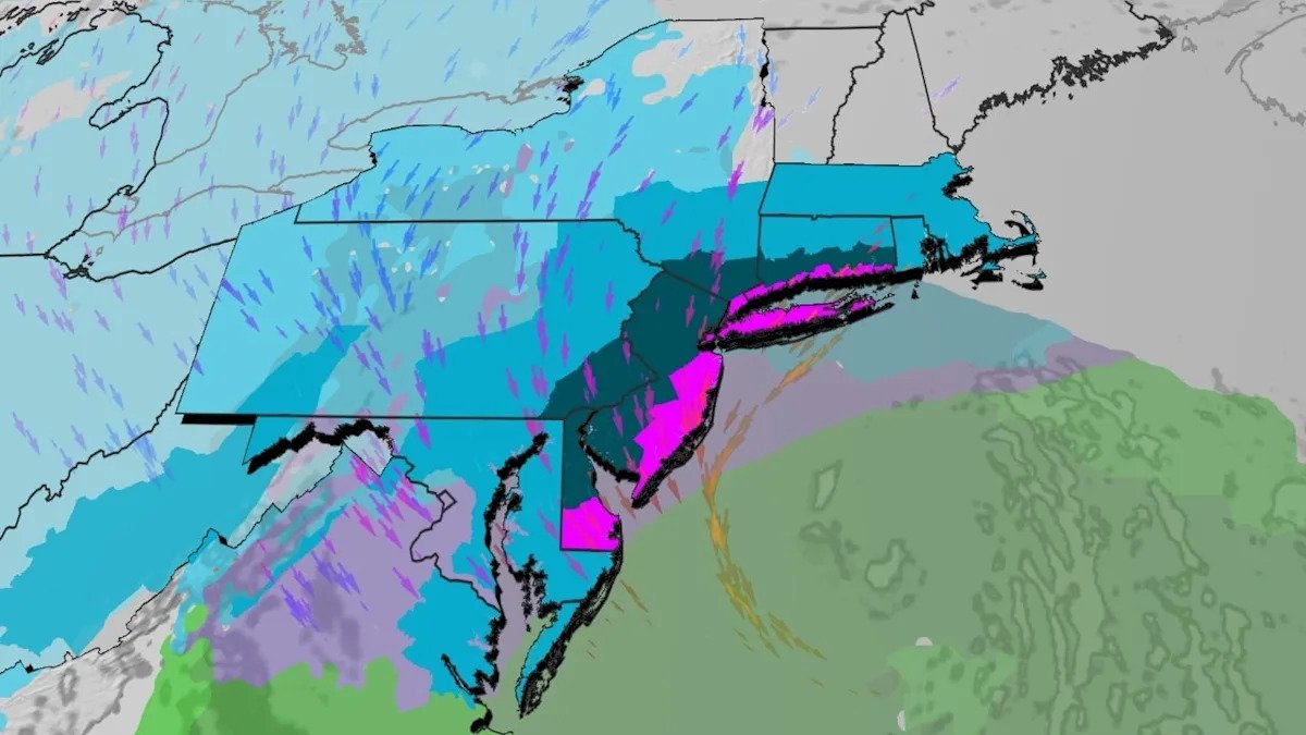
The Forecast
The maps below show our current forecast of snow and rain from this system from Sunday through Monday. Each map also includes which cities will see the worst impacts.
Wind gusts over 40 mph are also increasingly likely from coastal Virginia to eastern Massachusetts. These strong onshore winds could cause coastal flooding on Sunday night and Monday morning at times of high tide.
Sunday
Snowfall will expand through much of the interior Northeast while mixing with rain from New Jersey and Maryland southward. This mixture may quickly turn over to a thumping heavy, wet snow by late in the day across parts of the mid-Atlantic. Temperatures will remain high enough for rain to be the main threat on the southernmost end of the storm, specifically for parts of the Carolinas and southern Virginia.
Cities To See Winter Weather: Washington, D.C., Philadelphia, Baltimore, Atlantic City, New York City

Sunday Night
Temperatures drop so that all major metropolitan areas will see snow. Snow will begin in New England.
Snowfall rates will eclipse one inch per hour at times, especially closer to the coast. In some locations, combined with gusty winds, this will lead to scattered power outages. Reduced visibility will make travel in the latter half of the weekend into Monday dangerous.
For New York City and Philadelphia, the winds and snow will be at their worst through this time.
Should New York City see over a foot of snowfall in 1 day, it would be the first time they have seen this much snowfall since February 1, 2021. Although less likely for Philadelphia, should they see a foot in 1 day, it would be the first time since 2016.
Coastal flooding at high tide Sunday night into early Monday is possible from coastal Massachusetts to Delaware.
Cities To See Winter Weather: Washington, D.C., Baltimore, Philadelphia, Charleston, New York City, Boston

Monday
Snowfall will begin to wrap up for the Mid-Atlantic but will continue for the Northeast. Gusty winds in place mean that whiteout conditions are possible even after new snowfall has stopped.
This storm will have impacts on Monday morning’s commute from Philadelphia to Boston, and possibly the evening commute in parts of New England. If you can stay off the roads, please do so.
Boston will see its heaviest snow and its gustiest winds through the day on Monday.
Power outages from New England to New Jersey are increasingly likely.
Cities To See Winter Weather: Philadelphia, New York City, Boston

This forecast may still change slightly, but if you are in any of the blue or purple in the maps above, expect hazardous conditions and delays. Check back with us at weather.com for updates to this forecast.
How Much Snow?
The heaviest snow is expected along the coast from New Jersey to Massachusetts and in the northern Appalachians, where totals will surpass a foot.
This will be a heavy, wet, “heart attack” kind of snow that will weigh down powerlines, roofs and trees. Please take care of yourself while shoveling.
(MORE: “Heart Attack” Snow)
Note that as this forecast continues to get refined, these totals could still shift. Should the storm move further west in future model runs, some places could see even more snowfall than this map shows right now.

(MORE: Why Northeast Winter Storms Can Be Difficult To Forecast)
Note that for some of the major cities, it has been an above-average snowfall this winter. Boston has seen over 8 inches more than average with a snowfall total of 42.5 inches so far. This is significantly higher than the 28.1 inches the city saw last year.
New York City, specifically Central Park, has seen 22.3 inches of snowfall so far this year. Compare this to last year, where they saw only 12.9 inches.
Jonathan Erdman is a senior meteorologist at weather.com and has been covering national and international weather since 1996. Extreme and bizarre weather are his favorite topics. Reach out to him on Bluesky, X (formerly Twitter) and Facebook.