
Breaking News
Winter storm to bring heavy snow and ice this weekend across the southern and eastern U.S.
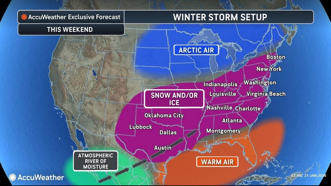
A major winter storm is forecast to bring heavy snow, sleet, freezing rain and frigid temperatures from Texas to Massachusetts through the weekend, according to meteorologists. It’s expected to affect more than 180 million Americans and could become one of the most significant storms of this winter season.
Major metro areas in the storm’s path include Dallas, Austin, Oklahoma City, Nashville, Atlanta, Charlotte, Washington, D.C., Baltimore, Philadelphia, New York City and Boston, forecasters say.
Impacts from the snow and ice could cause power outages, widespread travel shutdowns and school closures. Following the storm, frigid temperatures will prolong the impacts of the snow and ice. “Potentially hundreds of thousands of people may go without electricity and heat for days,” AccuWeather chief meteorologist Jonathan Porter said.
Winter storm watches have been issued for at least 70 million people from New Mexico to North Carolina and as far south as Texas, according to the National Weather Service. The agency advises people to “start preparations now for an impactful and prolonged winter storm.”
How much snow and ice is expected — and where?

Predicted snow totals.
Heavy snow
“Expect heavy snow for the Southern Rockies and the south-central Plains eastward through the mid-Atlantic,” the weather service said. “Snow-covered roads and low visibility will cause widespread travel disruptions.”
In the Central Plains, 6 to 12 inches are forecast, with over 2 feet possible in parts of the Appalachians. Snow totals in the Northeast will depend on the storm’s exact track, but a significant and plowable amount is possible, meteorologists say.
Ice accumulation
“Broad swaths of freezing rain and sleet are expected south of the all-snow zone over the Southern Plains, Mid-South and Carolinas,” the NWS said. “Treacherous travel conditions, prolonged power outages and tree damage are likely.”
In the South, a thick glaze of ice will sweep across Texas to the Carolinas, which will weigh down trees and power lines.
What are the timing and impacts of the storm?

Storm impacts forecast for Friday.
Friday
The Plains will be impacted by snow, sleet and freezing rain by late morning or early afternoon, according to the Weather Channel. This includes parts of Kansas, Oklahoma and northern and western Texas and could extend as far east as western Tennessee and northern Mississippi.
Saturday
Snow, sleet and freezing rain could dip farther south in Texas, Louisiana and Mississippi while the storm heads toward the Northeast, affecting Kentucky, Tennessee, West Virginia and parts of the Carolinas.
Sunday
By midday, Texas, Oklahoma and the lower Mississippi Valley will see an end to the wintry precipitation mix. But it will continue from the Ohio Valley, Virginia and the Carolinas into the Northeast. Heavy snow is forecast in parts of the Ohio Valley and Northeast. Snow and wind in the Northeast are expected to continue into Monday morning.
How about travel disruptions and school closures?
More than 4,000 flight cancellations are to be expected nationwide this weekend due to the heavy snow and ice buildup, according to AccuWeather. School closures are also likely across multiple states as the storm lingers in some areas.