Breaking News
Winter Storm Chan To Bring New Snow To Midwest, Then Target Northeast Early This Week

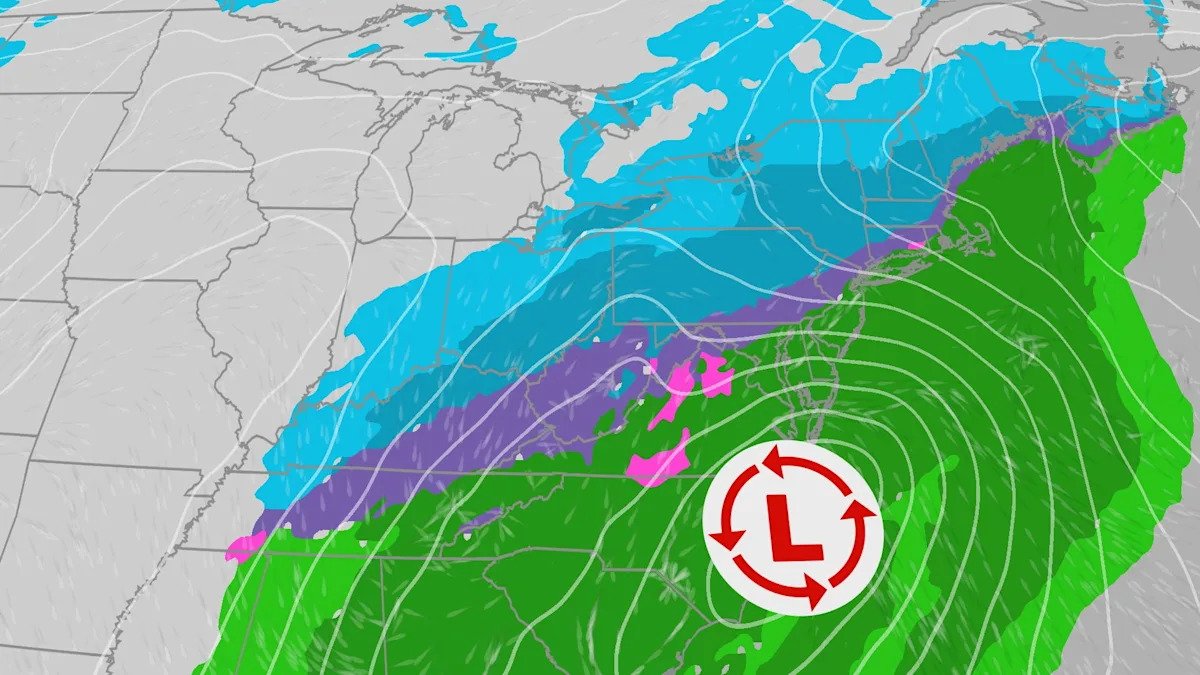
A new winter storm, Winter Storm Chan, will bring more snow to the Midwest and Great Lakes after Winter Storm Bellamy continues to impact holiday travel. Then Chan will set its sight for the Northeast, potentially bringing widespread icing and significant snow to the region Tuesday into Wednesday morning.
Set-Up
Confidence is increasing that Winter Storm Chan will be an impactful storm for millions as all ingredients are in place.
Cold air (at the surface and aloft)
Abundant moisture streaming in from the Gulf
Area of low pressure – which has the potential to strengthen and intensify off the East Coast
One-Two Punch For Midwest, Great Lakes
Winter Storm Chan will bring another round of new snow to the Midwest and Great Lakes Monday into Monday night. This comes after Winter Storm Bellamy dumped double digit snowfall amounts across a large swath of the Midwest on Saturday. Chicago O’Hare reported 8.4″ of snow, making it the snowiest November day on record.
The silver lining… Chan will not be a blockbuster storm for this region of the country. However, any additional snow will impact travel.

Good news for the kiddos…the snow will stick around for a while as highs won’t make it above freezing for the entire week. The upper level pattern will feature reinforcing shots of cold air every few days, leading to a stretch of cold and unsettled weather for many across the Midwest and Great Lakes.
(MAPS: 10-Day US Forecast Highs/Lows)
Icing Potential
There is going to be a transition zone that sets up somewhere in the Ohio Valley Monday night into Tuesday morning. This is where warm air aloft will be overriding the cold air at the surface. This will result in a mix of rain, sleet and freezing rain. Right now, models are showing a potential mix in places like Little Rock, Louisville, Paducah, Lexington, however the better chances for widespread icing look to be in the central and southern Appalachians.
1st Measurable Snow For I-95 Cities?
It’s definitely a possibility! Boston, Providence, NYC and Philadelphia have already seen their first flakes of the season, but none of these cities have reported any measurable snow (0.1” or greater) yet this season.
But there is still quite a bit of uncertainty.

What We Know:
Models are showing an area of low pressure developing along the Gulf Coast early Tuesday. This low is forecast to move northeast and intensify off the mid-Atlantic coast late Tuesday into Wednesday. While Winter Storm Chan has potential to produce significant snow for the Northeast, there is still a lot of uncertainty when it comes to where the heaviest snow will fall at this point. Northeast storms can notoriously be extremely difficult to forecast.
(MORE: Why Northeast Winter Storms Are Hard To Forecast)
What We Don’t Know:
The exact track and the intensity the storm. Models are in disagreement on how strong the low will get and the track of the low, which makes a huge difference in where the rain/snow line sets up – crucial in determining snow totals
The European model shows the low taking a more eastern track, as well as not getting as strong, which paints lower totals overall, with higher totals focused further south.

Meanwhile, the GFS model takes the low farther north, which pushes the rain/snow line farther north and the accumulating snow to the interior portions of the Northeast. This is when the I-95 corridor misses out.

What You Should Do
Stay up to date with the latest forecast here and think about how you would prepare if snow were to head your way. Models will change over the next few days and the area of heaviest snow will shift as well. Remember the saying, “the trend is your friend.” Once we see more consistency and agreement within the models, we will have a better idea on where the worst impacts will be.
Tiffany Savona is a meteorologist for weather.com with more than 15 years of experience in forecasting the weather across the country.
Miriam Guthrie graduated from the Georgia Institute of Technology with an undergraduate degree in Atmospheric and Oceanic Sciences and is now a meteorology intern with weather.com while working toward her master’s.
