
Breaking News
A nor’easter could impact the East Coast starting this weekend and early next week. See its path and the latest forecast.
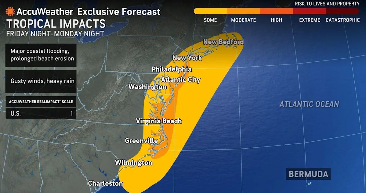
A powerful storm off the East Coast with tropical winds and rains could develop into a nor’easter over the weekend into Monday. It’s forecast to bring heavy rain, gusty winds, rough surf and coastal flooding.
“A coastal low is expected to develop off the Carolinas late this week and strengthen this weekend,” the National Weather Service said Thursday. “This strengthening storm may bring significant impacts to much of the U.S. East Coast through early next week.”
Coastal flood watches and advisories have been put in place in various parts of the East Coast.
Meteorologists also say that the storm could evolve into a named tropical storm designated by the National Hurricane Center, which would happen if it reaches maximum sustained winds of at least 39 mph. Next up on the list of names for the 2025 Atlantic hurricane season is Karen.
“A fully tropical storm gets its energy solely from the ocean. A subtropical or hybrid storm gets its energy from both the ocean and the jet stream or stalled front,” explained AccuWeather lead hurricane expert Alex DaSilva. “We think this will be a hybrid storm as a result.”
AccuWeather meteorologists say that the storm could resemble powerful nor’easters that power up the Atlantic coastline during the winter, minus the snow.
Nor’easters are large, intense areas of low pressure that can produce heavy rain, heavy snow, severe coastal flooding or even blizzard conditions in the East. They typically develop off the East Coast during the late fall, winter and early spring.
This weekend’s storm would technically be a nor’easter, since the winds are coming out of the Northeast.
Here’s what else to know about the severe weather targeting the East Coast.
What is the storm’s path?
According to a Thursday forecast discussion from the NWS, “A front will linger across northern Florida and along the Gulf Coast through the weekend, bringing daily chances for showers and thunderstorms to Florida.”
The storm is then expected to form off the coast of Georgia and South Carolina late this week and will move northward over the weekend to early next week.
“As the storm drifts to the north, it will grow stronger each day,” AccuWeather chief meteorologist Bernie Rayno said.
“There is a high risk this storm will be designated a subtropical (hybrid) storm, which is why we have designated this system as a tropical wind and rainstorm, and have issued an eye path map to raise early awareness, ahead of potential National Hurricane Center (NHC) classification,” DaSilva explained.

The anticipated path of the storm targeting the East Coast this weekend. (AccuWeather)
Potential impacts and timing
“This will be a damaging storm for some along the Atlantic Coast,” said Rayno.
Possible significant coastal flooding
Potentially major coastal flooding is also possible from the Carolinas to the Northeast Seaboard, according to the Weather Channel.
“The combination of persistent, strong onshore winds, high surf, and high astronomical tides may lead to some East Coast communities experiencing significant coastal flooding impacts,” the NWS said. Residents in these areas are advised to follow their local forecasts and guidance from local officials.
Strong wind gusts and heavy rain
The NWS said that the storm could also “bring wind gusts in excess of 45 mph and periods of heavy rain, primarily to areas near the coast.” Additional flooding from rain outside the coastal zone could also cause scattered power outages.
“Along the immediate coast, winds are likely to get strong enough with this from southeastern Virginia to Delmarva-New Jersey and southeastern New York — and possibly southern New England — to lead to tree, power line and property damage,” said AccuWeather senior meteorologist Dave Dombek.
High surf could cause strong rip currents and beach erosion
Since this storm is expected to move slowly, many East Coast beaches are likely to see high surf conditions, which will cause strong rip currents and could lead to some beach erosion.