
Breaking News
See the projected path as latest forecast says Southeast coast could see heavy rain and flooding
Imelda became the fourth hurricane of the 2025 Atlantic hurricane season on Tuesday, according to the National Hurricane Center. While it’s not expected to make landfall in the United States, forecasters say parts of the Southeast are expected to experience heavy rainfall, flooding, storm surge, and dangerous surf impacts, prompting the governors of South Carolina and North Carolina to declare a state of emergency.
By Wednesday afternoon, tropical storm conditions are possible over Bermuda, with hurricane conditions expected by Wednesday evening. Up to 4 inches of rainfall is expected across Bermuda from Wednesday into Thursday, which could cause flash flooding.
Forecasters are also monitoring the path of Hurricane Humberto, which is a Category 1 storm that’s moving north-northwest in the Atlantic Ocean. It’s expected to produce dangerous surf and rip currents along the U.S. East Coast this week.
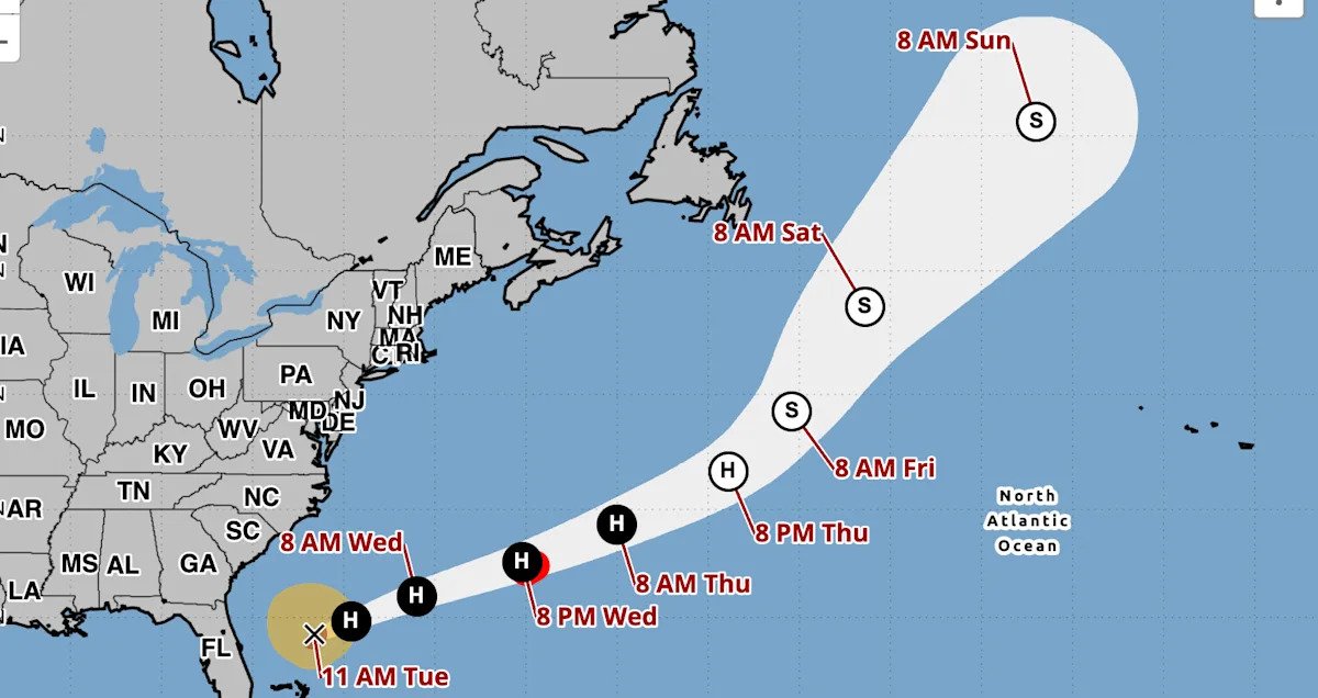
Where is Hurricane Imelda, and what is its path?
As of 11 a.m. ET Tuesday:
Imelda was located about 735 miles west-southwest of Bermuda.
The storm has maximum sustained winds of 80 mph.
It is moving northeast at 7 mph.
Imelda is expected to continue to move northeast, with the center of the storm moving away from the northwestern Bahamas. Over the next few days, it’s forecast to make a sharp turn to the east-northeast. By midweek, Imelda is expected to move away from the southeastern U.S., but will approach the island of Bermuda by Wednesday afternoon.
What are the storm’s expected impacts?
In addition to heavy rainfall, a storm surge triggered by Imelda could cause minor coastal flooding, the National Hurricane Center said in its latest advisory. The water could reach 1 to 2 feet above ground from the Volusia/Brevard County Line in Florida to the South Santee River in South Carolina if the surge happens over the next several high tide cycles, forecasters say.
Watches and warnings in place
These are the current advisories in place, according to the NHC:
A hurricane warning is in effect for:
Forecasters added that, “A Hurricane Warning means that hurricane conditions are expected somewhere within the warning area. A warning is typically issued 36 hours before the anticipated first occurrence of tropical-storm-force winds, conditions that make outside preparations difficult or dangerous. Preparations to protect life and property should be rushed to completion.”
Could Humberto and Imelda combine to form one storm?
Humberto and Imelda could become part of a weather phenomenon known as the Fujiwhara Effect, which is what happens “when two hurricanes spinning in the same direction pass close enough to each other, they begin an intense dance around their common center,” the National Weather Service said.
In this instance, the Fujiwhara Effect could help prevent the U.S. East Coast from getting slammed.
“The rare Fujiwhara Effect between Humberto and Imedla is expected to help spare the Southeast U.S. from widespread flooding rainfall,” said AccuWeather’s lead hurricane expert, Alex DaSilva. “The influence from the much stronger and larger Humberto will tug at Imelda and help pull the storm away from the U.S. and out to sea.”
“It’s quite rare to see the Fujiwhara Effect in the Atlantic basin. The interaction between the two storms should prevent Imelda from making landfall or stalling near the coast, which could have led to days of torrential rainfall and widespread flooding,” DaSilva added. “The impacts could have been catastrophic.”