
Breaking News
Maps show Hurricane Lorena’s path and forecast in Pacific
One of two hurricanes churning over the Pacific Ocean early Wednesday could bring heavy rain and perhaps “life-threatening flash floods and mudslides” to Mexico’s Baja California peninsula later in the week, though possibly as a tropical storm, forecasters said.
Hurricane Lorena just hit hurricane strength, the U.S. National Hurricane Center in Miami said but “rapid strengthening” is likely through tonight. Then, the center said, “fast weakening is expected to start on Thursday, and Lorena could weaken back to a tropical storm by Friday.”
As of Wednesday morning, Lorena was located south-southwest of Cabo San Lucas, Mexico, with maximum sustained winds of 75 mph — barely hurricane status.

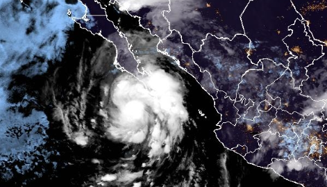
Hurricane Loreno off Mexico, as seen by a satellite early on Sept. 3, 2025. / Credit: NOAA
A second Pacific hurricane — Kiko — was much stronger but farther out to sea and posing no threat to land.
Maps show Hurricane Lorena’s forecast path
The center of Lorena is forecast to “move parallel to the west coast of the Baja California peninsula today and Thursday and then approach the coast Thursday night and Friday,” according to the hurricane center.

Hurricane Lorena’s projected path as of 4 a.m. EDT on Sept. 3, 2025 / Credit: NOAA
Warnings issued due to Hurricane Lorena
Mexico’s government posted a tropical storm warning for Baja California Sur’s west coast from Santa Fe to Cabo San Lazaro, and a tropical storm watch for Baja California Sur’s coast north of Cabo San Lazaro to Punta Abreojos.
Hurricane Lorena’s possible impact
Parts of Baja California Sur and far southeast Baja California could get 5 to 10 inches of rain with as much as 15 inches through Friday, the hurricane center. “This will bring the risk of life-threatening flash floods and mudslides, especially in areas of higher terrain,” the hurricane center said.
Hurricane Kiko much stronger but not seen as threat to land
Hurricane Kiko was already a Category 2 storm with maximum sustained winds of 105 mph early Wednesday and was forecast to get even stronger and become a major hurricane later in the day, the hurricane center said. That would make it a Category 3, with maximum sustained winds between 111 and 129 mph.
But the center said Kiko wasn’t expected to hit land.
Sneak peek: Murder at Sea?
Epstein survivor hints at potential list of names being compiled by accusers
Watch: Lava shoots out of Hawaii’s Kilauea volcano in latest eruption